Saffir Simpson Scale | Tropical Weather | National Meteorological Service of Belize
The National Meteorological Service presently provides forecast products for the general public along with those for maritime and aviation interests.
At a glance
About this Belize website
The National Meteorological Service presently provides forecast products for the general public along with those for maritime and aviation interests.
- Publisher
- nms.gov.bz
- First discovered
- 13 September 2026
- Last checked
- 14 September 2026
Information found on this page
Highlights and services
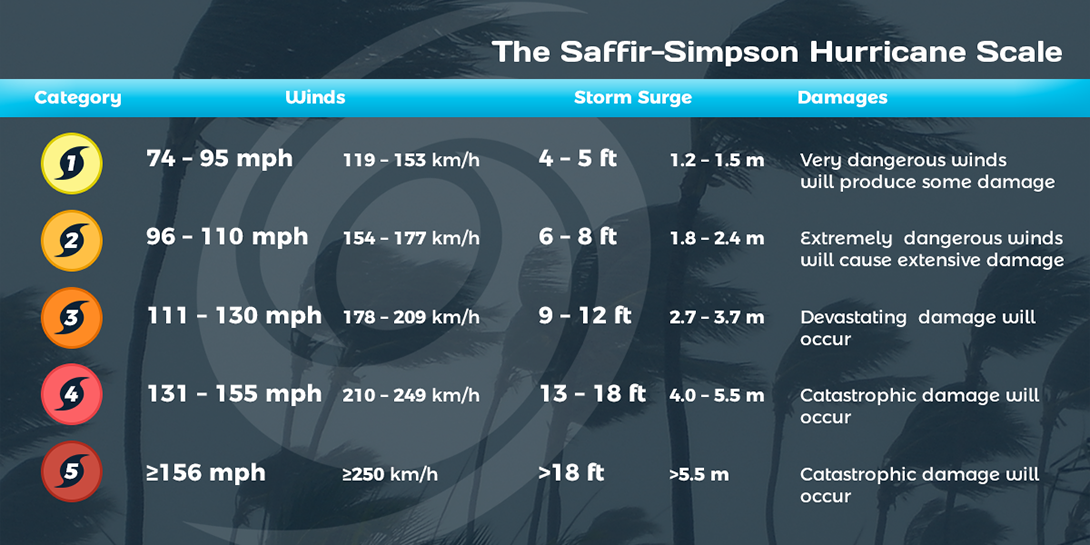
Category One Hurricane:
Winds 74-95 mph (64-82 kt or 119-153 km/hr). Storm surge generally 4-5 ft above normal. No real damage to building structures. Damage primarily to unanchored mobile homes, shrubbery, and trees. Some damage to poorly constructed signs. Also, some coastal road flooding and minor pier damage. Examples of category 1 hurricanes are Abby (July 1960) and Anna (July 1961) which affected southern Belize.
Category Two Hurricane:
Winds 96-110 mph (83-95 kt or 154-177 km/hr). Storm surge generally 6-8 feet above normal. Some roofing material, door, and window damage of buildings. Considerable damage to shrubbery and trees with some trees blown down. Considerable damage to mobile homes, poorly constructed signs, and piers. Coastal and low-lying escape routes flood 2-4 hours before arrival of the hurricane center. Small craft in unprotected anchorages break moorings. Francelia (Sept 1969) was a category 2 hurricane which impacted on southern Belize. Other notable Category 2 hurricanes Fifi (Sept 1974) which impacted southern Belize and Greta (Sept 1978) which made landfall along the central coast.
Category Three Hurricane:
Winds 111-130 mph (96-113 kt or 178-209 km/hr). Storm surge generally 9-12 ft above normal. Some structural damage to small residences and utility buildings with a minor amount of curtain wall failures. Damage to shrubbery and trees with foliage blown off trees and large trees blown down. Mobile homes and poorly constructed signs are destroyed. Low-lying escape routes are cut by rising water 3-5 hours before arrival of the center of the hurricane. Flooding near the coast destroys smaller structures with larger structures damaged by battering from floating debris. Terrain continuously lower than 5 ft above mean sea level may be flooded Hurricanes Carmen (Sept 1974) which passed north of north